A navigation mesh only describes a traversable area for an agent's center position. Any radius values an agent may have are ignored.
If you want pathfinding to account for an agent's (collision) size you need to shrink the navigation mesh accordingly.
Navigation works independently from other engine parts like rendering or physics.
Navigation meshes are the only things considered when doing pathfinding, e.g. visuals and collision shapes for example are completely ignored by the navigation system.
If you need to take other data (like visuals for example) into account when doing pathfinding, you need to adapt your navigation meshes accordingly.
The process of factoring in navigation restrictions in navigation meshes is commonly referred to as navigation mesh baking.
If you experience clipping or collision problems while following navigation paths, always remember that you need to tell the navigation system what your intentions are through an appropriate navigation mesh.
By itself the navigation system will never know "this is a tree / rock / wall collision shape or visual mesh" because it only knows that "here I was told I can path safely because it is on a navigation mesh".
Navigation meshes in the 2D editor are created with the help of the NavigationPolygon draw tools
that appear in the top bar of the editor when a NavigationRegion2D is selected.
The NavigationPolygon draw tools can be used to create and edit navigation meshes by defining outline polygons.
The outline polygons are later converted to real navigation mesh resources for the NavigationServer regions.
Multiple outlines can be added to the same NavigationPolygon resource as long as they do not intersect or overlap.
Each additional outline will cut a hole in the polygon created by the larger outline.
If the larger polygon is already a hole, it will create a new navigation mesh polygon inside.
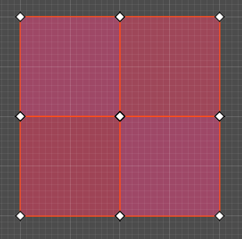
Outlines are not a replacement if the intention is to merge aligned polygons e.g. from grid cells.
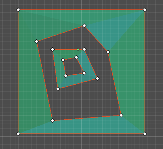
Outlines, as the name would suggest, cannot intersect each other or have any overlapping vertex positions.
Outline layouts like seen in this picture will fail the convex partitioning required by the navigation mesh generation.
In these layout cases, the outline tool cannot be used. Use the Geometry2D class to merge or intersect polygons to create a merged mesh that is valid for navigation.
Nota
The NavigationServer does not connect navigation mesh islands from the same navigation mesh resource.
Do not create multiple disconnected islands in the same NavigationRegion2D or NavigationPolygon resource if they should be later connected.
For 2D, no similar navigation mesh baking with geometry parsing exists like in 3D.
The Geometry2D class functions for offset, merge, intersect, and clip can be used to shrink or enlarge existing NavigationPolygons for different actor sizes.
Navigation meshes in the 3D editor are created with the help of the
NavigationMeshGenerator singleton
and the NavigationMesh bake settings that appear in the editor inspector.
Navigation mesh baking is the process of creating a simplified mesh used for pathfinding out of (complex) 3D level geometry.
For this process Godot parses scene geometry and hands the raw mesh or collision data to the
third-party ReCast library for processing and creation of the final navigation mesh.
The resulting navigation mesh is an approximation of the source geometry surfaces
for both performance and technical reasons. Do not expect the navigation mesh
to perfectly follow the original surfaces. Especially navigation polygons placed
over ramps will not keep an equal distance to the ground surface. To align an
actor perfectly with the ground use other means like physics.
Aviso
Meshes need to be triangulated to work as navigation meshes. Other mesh face formats like quad or ngon are not supported.
To rebake a NavigationMesh at runtime, use the NavigationRegion3D.bake_navigation_mesh() function.
Another option is to use the NavigationMeshGenerator.bake() singleton function with the NavigationMesh resource directly.
If the NavigationMesh resource is already prepared, the region can be updated with the NavigationServer3D API directly as well.
extendsNavigationRegion3Dfuncupdate_navigation_mesh():# use bake and update function of regionvaron_thread:bool=truebake_navigation_mesh(on_thread)# or use the NavigationMeshGenerator singletonvar_navigationmesh:NavigationMesh=navigation_meshNavigationMeshGenerator.bake(_navigationmesh,self)# remove old resource first to trigger a full updatenavigation_mesh=nullnavigation_mesh=_navigationmesh# or use NavigationServer API to update region with prepared navigation meshvarregion_rid:RID=get_region_rid()NavigationServer3D.region_set_navigation_mesh(region_rid,navigation_mesh)
Nota
Baking a NavigationMesh at runtime is a costly operation.
A complex navigation mesh takes some time to bake and if done on the main thread can freeze a game.
(Re)baking a large navigation mesh is preferably done in a separate thread.
Aviso
Property values on a NavigationMesh resource like cell_size need
to match the actual mesh data stored inside in order to merge
different navigation meshes without issues.
NavigationRegion2D and NavigationRegion3D both use meshes to mark traversable areas, only the tools to create them are different.
For 2D, NavigationPolygon resources are used to draw outline points in the editor. From these outline points the NavigationServer2D creates a mesh to upload navigation data to the NavigationServer.
For 3D, NavigationMesh resources are used. Instead of providing draw tools the 3D variant
provides an extensive amount of parameters to bake a navigation mesh directly from 3D source geometry.
Nota
Technically there is no hard distinction between 2D and 3D on how to use the given toolsets to create flat navigation meshes. The 2D drawing tool can be used to create a flat 3D navigation mesh and the 3D baking tool can be used to parse flat 3D geometry into appropriate 2D navigation meshes.
The following script parses all child nodes of a NavigationRegion2D for CollisionPolygons
and bakes their shape into the NavigationPolygon. As the NavigationPolygon creates the
navigation mesh from outline data the shapes cannot overlap.
The following script creates a new 2D navigation region and fills it with procedurally generated navigation mesh data from a NavigationPolygon resource.
The following script creates a new 3D navigation region and fills it with procedurally generated navigation mesh data from a NavigationMesh resource.
extendsNode3Dvarnew_3d_region_rid:RID=NavigationServer3D.region_create()vardefault_3d_map_rid:RID=get_world_3d().get_navigation_map()NavigationServer3D.region_set_map(new_3d_region_rid,default_3d_map_rid)varnew_navigation_mesh:NavigationMesh=NavigationMesh.new()# Add vertices for a triangle.new_navigation_mesh.vertices=PackedVector3Array([Vector3(-1.0,0.0,1.0),Vector3(1.0,0.0,1.0),Vector3(1.0,0.0,-1.0)])# Add indices for the polygon.new_navigation_mesh.add_polygon(PackedInt32Array([0,1,2]))NavigationServer3D.region_set_navigation_mesh(new_3d_region_rid,new_navigation_mesh)
The following script creates a new 3D navigation mesh for each GridMap items, clears the current grid cells, and adds new procedural grid cells with the new navigation mesh.
extendsGridMap# enable navigation mesh for grid itemsset_bake_navigation(true)# get grid items, create and set a new navigation mesh for each item in the MeshLibraryvargridmap_item_list:PackedInt32Array=mesh_library.get_item_list()foritemingridmap_item_list:varnew_item_navigation_mesh:NavigationMesh=NavigationMesh.new()# Add vertices and polygons that describe the traversable ground surface.# E.g. for a convex polygon that resembles a flat square.new_item_navigation_mesh.vertices=PackedVector3Array([Vector3(-1.0,0.0,1.0),Vector3(1.0,0.0,1.0),Vector3(1.0,0.0,-1.0),Vector3(-1.0,0.0,-1.0),])new_item_navigation_mesh.add_polygon(PackedInt32Array([0,1,2,3]))mesh_library.set_item_navigation_mesh(item,new_item_navigation_mesh)mesh_library.set_item_navigation_mesh_transform(item,Transform3D())# clear the cellsclear()# add procedural cells using the first itemvar_position:Vector3i=Vector3i(global_transform.origin)var_item:int=0var_orientation:int=0foriinrange(0,10):forjinrange(0,10):_position.x=i_position.z=jgridmap.set_cell_item(_position,_item,_orientation)_position.x=-i_position.z=-jgridmap.set_cell_item(_position,_item,_orientation)